Why are bridges needed? Bridges in people's lives
Research work on geography
on the topic: "Bridges of the world".
Completed:
Petrova Alina,
Butsenko Ksenia,
7th grade students.
Supervisor:
Petrova Lyudmila Anatolyevna,
Geography teacher MOU secondary school №3
Strezhevoy 2008
Of all that man raises and builds,
obeying the instinct of life, in my opinion,
there is nothing better and more valuable than bridges.
During his life, a person overcomes thousands of paths and roads. But there are no straight and smooth roads in the world. Almost always, obstacles in the form of rivers, insurmountable mountains and gorges stand in the way of a person.
In our lives, we often overcome obstacles across bridges, sometimes not even noticing these inconspicuous and modest structures, and sometimes admiring their grandiosity and great significance.
What exactly is a bridge? What are they needed for? What role was assigned to bridges at all times of their existence? Can humans do without bridges? How do bridges affect social life? Can the very existence of a bridge become a cornerstone in the life of human society?
These questions arose before us in the process of studying various information sources. The topic of bridges seemed relevant to us also due to the fact that it is relevant for our city of Strezhevoy.
The purpose of our work: to conduct a study - why a person needs bridges.
Tasks: 1) explore information sources on the history of bridges; 2) to study the main classification and construction of bridges in Russia and the world; 3) determine the main value of bridges; 4) determine what problems the city of Strezhevoy has due to the lack of a bridge? 5) Create a slide presentation on the results of the study.
We believe that our work will be of interest to a wide range of students of our school, and can also be used by elementary school teachers when conducting lessons on the world around, geography teachers when conducting country studies lessons in grades 7, 10-11, teachers of history, fine arts, physics and etc.
Although modern bridges are rather complex engineering structures, most of them are built according to the old, time-tested principle. First, the supports are installed, on which the superstructures are then lowered.
The forms of supports can be very diverse. Intermediate supports are called bulls, coastal - abutments. Materials for bridges are metal (steel and aluminum alloys), reinforced concrete, concrete, natural stone, wood. Bridges are classified by application and by design.
By area of application, bridges are divided into:
- Railway
- Automotive
- metro bridges
- Pedestrian
- Combined (for example, road and rail).
There are also pipeline bridges, aqueducts (used to transport water) and viaducts (bridges over ravines or gorges; connect points of equal height).
By design, bridges are divided into:
The meaning of bridges is multifaceted:
- Allow to overcome geographical barriers of relief and hydrology
(rivers, gorges, ravines, canyons, cliffs, etc.);
- They are connecting elements of transport routes (railways and roads);
- Improve the geographical position of the territory;
- Influence the transport accessibility of settlements;
- They are strategic military facilities that allow them to penetrate the territory as soon as possible;
- Are historical and cultural monuments;
- They are an integral part of urban architecture.
Famous and unusual bridges of the world and Russia.
The world's largest wooden bridge, over two kilometers long, is located in Burma.
The Nanpu Bridge is the first large bridge on the Huangpu River. Like a majestic dragon, it hovers over the new district of Shanghai.
The most famous suspension bridge in Russia is the Crimean bridge. The Krymsky Bridge, thrown across the Moscow River and connecting Krymskaya Square with Krymsky Val Street, immediately after the opening became one of the largest suspension bridges in Europe. Today, the Crimean bridge is on the list of protected cultural heritage sites of the capital.
At the end of December last year, a new cable-stayed bridge was opened in the capital, thrown over the Moscow River in the Serebryany Bor area. Its name is "Picturesque"
Quite recently, the city authorities announced plans to build an automobile cable-stayed bridge near the Moscow City business center, which is designed to solve the transport problems of the capital.
Surgut cable-stayed bridge across the Ob River, opened in 2000, with a total length of 2110 m, it has the largest span in the world (408 m), supported by one pylon.
Palace Bridge Petersburg - the main bridge of the Russian Empire
The longest bridge- a 4 km long crossing over the Yuribey river delta is being built by Russian builders on the Yamal Peninsula
The Syzran Bridge across the Volga is 120 years old.
Millau Viaduct the highest bridge in the world. Its length is more than two and a half kilometers. And one of the pillars of the bridge rises to 343 meters. The French are very proud of him.
Our city is also not spared the problem of building a bridge. And for our city, it is also necessary, as in Moscow, Japan or France. Or maybe this is a whim of a provincial town and a desire to attract attention? Why do we need this bridge so much?
This problem has been around for decades. And if the country's authorities have not completed the railway and Strezhevoy, then they should provide a bridge over the Vakh River. The only way to get to Strezhevoy, the oil capital, by land is through Nizhnevartovsk. Two cities of different Russian regions are separated by only 70 kilometers. It is not without reason that the residents of Strezhezhev call them the road of life. Today, residents of Strezhevoy, in order to get to Nizhnevartovsk, need to overcome a water obstacle - the Vakh River. In winter - on a pontoon bridge, in summer - on barges
Where does this path of life lead? To the International airport, railway station, federal highway. Let's add, to educational institutions, good doctors, finally, shops and entertainment. In a word, to civilization. There is only one road from Strezhevoy - to Nizhnevartovsk through the ferry. You can't go anywhere else from Strezhevoy. And you don't fly by plane.
Three hundred meters of the Vakh River have not been subdued by the inhabitants of the northern regions of the Tomsk region for forty years. What is the significance of the construction of the bridge for our city?
Firstly, it is the transport accessibility of our city. After all, our city is the northernmost in the Tomsk region, cut off from the regional center by more than 700 km,
Secondly, the lack of a road greatly affects the geographical position of our city - this worsens it. Who would want to invest capital in the development of our city, if the cost of a toll crossing over the bridge must be added to the cost of each product or service. All this greatly affects the social and economic development of our city. Every year, the city budget of Strezhevoy loses from 15 to 18 million rubles at the crossing
Thirdly, if there is no development in Strezhevoy, the oil city, then there is no development in the entire economy of the Tomsk region.
The problem of the bridge is a painful brainchild of the former mayor of Strezhevoy Alexei Troshin. “Strezhevoy cannot develop without this bridge. This is the most important thing for us. The bridge removes all problems, including the safety of living,” the words of Alexei Troshin are more relevant than ever in our days. blockade.
The construction of a pontoon bridge - an alternative to the existing paid ferry crossing was the first significant step towards the final resolution of the issue of transport accessibility of the northern territories of the Tomsk region.
The problem of the bridge in Strezhevoy was caused by the suffering of its inhabitants. And let the future bridge not go down in world history, but it will forever go down in the pages
history of Strezhevoy. We still believe that he will...
Conclusion
- We have achieved our goal - we have comprehensively studied the topic: "Bridges of the World" and determined why people need bridges. We have achieved our goal - we have comprehensively studied the topic: "Bridges of the World" and determined why people need bridges. Bridges are an integral part of modern civilization.
- If there were no bridges in the world, humanity could not rise to the current level of economic, social and aesthetic development for a long time to come.
- And the Dargin proverb says: "Which bridge you build, you will cross over it." People should remember this and leave behind only useful, necessary and beautiful bridges.
Bridges are engineering and technical structures, and they can be of a wide variety of shapes and have different purposes. Network, drawbridge, hanging, railway, automobile, pedestrian - these are all bridges.
Bridges are used to connect something or someone. The most common and ancient are bridges over rivers.
Everyone knows about the existence of drawbridges. Why are they needed? Why can't you build an ordinary bridge? This is due to the fact that a huge liner cannot pass under a simple bridge in height, so drawbridges are built at the shipping sites. They can diverge vertically (up) or horizontally (to the sides). The very first drawbridge was built over the River Thames.
The simplest type of bridge is a beam bridge. It serves to close a small empty space. There are even dental bridges! Bridge teeth are a prosthesis that must be installed if several or one tooth is missing. A prerequisite is the presence of two teeth on the sides of the installation site. The metro bridge is used for the metro line to pass through it.
Railway bridges are designed specifically for trains. Only pedestrians can cross the footbridges. Cars cannot drive over them, there are separate road bridges for them. The very first bridge appeared in ancient times and was a simple log thrown over a narrow abyss. In the future, these structures began to be built of stone.
Bridges were also used to provide the population with water. This type of structure is called an aqueduct. Some bridges are architectural works of art, therefore they serve not only as a means of crossing, but also as a decoration of the city. A multifunctional bridge has been built in Italy - in addition to its main function, it is planned to be used as a wind and solar power plant in the future (Wind and solar bridge "Solar Wind").
In Denver, a bridge was created specifically for animals. It connects two parts of the forest, which were separated by a highway. The longest bridge in the world was built in China and is 22 miles (35.41 km) long. It connects the shores of the ocean. This building is surprising in that a special service operates on it, where you can refuel the car, eat and spend the night.
A compass is an indispensable thing in a serious hiking trip. With the help of this useful device, equipped with a magnetic needle, the traveler can choose the right direction of travel without fear of getting lost in unfamiliar terrain. To prevent the compass from becoming a useless accessory, you need to know how to use it correctly.

What is a compass for?
People get out into nature quite often. For some, this is an opportunity to visit the forest in search of mushrooms and berries. Others love hiking in uncharted places. Untouched nature, fresh air, songs with a guitar by the fire and other attributes of romance, however, are good only when travelers feel confident in the forest. And for this you need to be able to navigate in unfamiliar places.
A person who is in a foreign city usually does not have problems with orientation in the area. In a large metropolis, it is quite easy to determine your location. This tourist will be helped by elements of urban infrastructure, signs with the names of streets or metro stations, and other information signs. To feel confident, it is enough to have at hand the most general map of the city.
Another thing is if you are in nature. There are no usual attributes of civilization here, and most often there is no one to ask for directions. And then the compass comes to the rescue. It is precisely the device with which you can relatively easily navigate in the field, in the mountains or in the forest, that is, where the wind of wandering has thrown you. This compact device, equipped with a dial and a magnetized needle, allows a trained tourist to confidently determine the sides of the horizon and outline the correct direction of movement.
To bring the compass into "combat readiness", remove it from the latch and place it on a horizontal plane. At the same time, the magnetized needle will be released and begin to oscillate, after which it will be fixed, pointing north with its blue end, and south with its red end. Now you need to turn the body of the device so that the zero on the dial coincides with the end of the arrow pointing north.
Please note that it is necessary to start orienteering not at the moment when you find yourself in a hopeless situation and get lost, but at the moment you start moving through unfamiliar terrain. Knowing the location of the sides of the horizon at the moment you enter the forest, you can immediately understand in which direction you will move. To return, of course, you will need to return in the opposite direction.
Using the marks printed on the compass dial, you can choose for yourself any direction of movement. In order not to get lost on a hike, it will only be necessary to remember or write down the azimuth to a noticeable landmark marked on the map or clearly visible on the ground. Azimuth is the angle, expressed in degrees, between the direction of north and the object you have selected. This angle, which can range from 0 to 360 degrees, is measured clockwise.
If you change direction along the way, you should each time measure a new azimuth using the compass, drawing a broken line on the map or traffic pattern. To learn how to work with a compass and a map, it is advisable to conduct one or two field exercises in an area with which you are relatively familiar. This skill, combined with a compass, will help you easily navigate where no human has gone before.
Attention, only TODAY!
All interesting
A compass is a device with which you can determine the cardinal points, remember your route and then exit in the right place. It is very useful, but only if you know how to use it. Learn how to use this device...
A compass is an indispensable thing in a serious hiking trip. With the help of this useful device, equipped with a magnetic needle, the traveler can choose the right direction of travel without fear of getting lost in an unfamiliar ...
Bridges perform not only a practical task, that is, they allow a person to cross from one coast to another, but also an aesthetic one - they can be an adornment of a city or area. Therefore, architects try to make bridges beautiful, and sometimes…
A water bridge is a structure designed to cross bodies of water by navigable vehicles. Under the reservoir understand the river or artificial channel. A water bridge cannot cross railway or road tracks, as it is more cost-effective…
In order to move according to the compass, it is necessary to determine the azimuth on the map. This is true for aircraft and ships making long flights and voyages. This is also true for hikers in conditions of poor visibility, at night, when…
Everyone at least once in their life had to walk in the forest and think about what to do if they get lost. You can navigate the terrain in different ways, there are many ways, the most common are a compass and well-visible objects of the environment ...
When orienting on the ground, it is very often necessary to move along predetermined directions, and not along the sides of the horizon. How can a compass help us with this? To move in the chosen direction, you will need the ability to calculate ...
For correct orientation on the ground and obtaining the desired direction of movement using a compass, it is necessary to determine the magnetic azimuth. Magnetic azimuth - a horizontal angle measured clockwise from the magnetic meridian ...
Focusing on the terrain on a hiking trip, fishing, and just when in an unfamiliar area, you often have to use not so much knowledge of the location of the cardinal points as arbitrarily chosen landmarks. To move around…
The word "azimuth" comes from the Arabic "as-sumut", which means "way", "direction". The most commonly used phrases with the word azimuth are the azimuth of a heavenly body and the azimuth of an earthly object. Azimuth is...
The image of divorced bridges is often used in poetry as a symbol of irresistible forces that do not allow lovers to be together. In life, the drawing of bridges occurs at a strictly allotted time and has no romantic reasons. The rivers where...
Kuzina S.V.
Throughout the development of human society, people have needed to move from place to place. Often rivers prevented this. For a convenient and safe passage through them, one had to look for a ford or go around. A person who saw fallen trees spread across the river came up with the idea of artificially creating such transitions. At first it was fallen trees, then they came up with rope devices. With the advent of the wheel, more reliable and durable structures were required. Thus the idea of bridges was born. The bridge is one of the most ancient inventions of mankind. It allows you to overcome obstacles in the form of a reservoir, a ravine, a collapse. At the same time, the bridge is a military-strategic facility and one of the most important means of communication.
In the culture of various societies, bridges had a spiritual meaning, which was created not only on the basis of their practical value and understanding of them as important parts of the infrastructure of states. Bridges have also become a symbol of human self-affirmation and overcoming the forces of nature. Today in the world there are more than a million bridges of different lengths, heights and beauty. It is difficult to overestimate their role in the modern international network of traffic flows, their great commercial and strategic importance.
One of the regions where today's transport and transit corridors cross is Kazakhstan. Acting due to its geographical position as an international crossroads of the most important trade routes along the North-South-West-East line, Kazakhstan is of great interest for the development of the economies of Asia and Europe. It is symbolic that in ancient times, the caravan routes of the Great Silk Road passed through its lands, which served as a road for cultural and trade cooperation between the peoples of East and West.
An important transport hub connecting the eastern region of Kazakhstan with large economic regions - Western Siberia, Altai, Mongolia, Western China, as well as other regions of Kazakhstan, is the city of Semipalatinsk (now the city of Semey). This is the second largest city in East Kazakhstan and a major railway junction located at the intersection of the Turkestan-Siberian railway, the Irtysh River and numerous highways. Of great importance in the transport system of the city are bridges over the Irtysh River, which divides the city into two parts. From the moment of formation, the Semipalatinsk fortress, founded in 1718 as a border and military base, as it grew, became an important trading point between Russia and Kazakhstan, and later between Russia, Central Asia and Western China. Dzungarian Kalmyks, Kokand, Bukhara, and Tashkent people came to the fortress to trade. Decade after decade, Semipalatinsk, becoming an increasingly important center of transit trade, not only passes through itself the industrial and exotic goods of Russia, China, India, Central Asia, but also successfully trades with these countries in leather, red yuft, meat, honey, produced in the Irtysh region .
Over time, as the region developed, economic ties expanded, it was necessary to build a large railway connecting Turkestan, Semirechye (today the south of Kazakhstan and part of Kyrgyzstan) and Siberia. The idea of building such a railway line was born in 1886. It was assumed that the road would strengthen the military presence of Russia in the region bordering China, as well as significantly simplify the export of cotton from Turkestan to Siberia and cheap Semirechensk and Siberian grain to Turkestan. In 1906, money was allocated for the construction of the Barnaul-Semipalatinsk-Verny-Lugovaya-Arys line. In 1907, the first geological and statistical-economic studies were carried out on the ground. Soon the construction of connecting lines from the Trans-Siberian Railway to Semipalatinsk began, which was carried out until 1917 and even during the years of the civil war. Separate branches were completed under the Bolsheviks in the early 1920s.
Despite the construction of railway lines in Kazakhstan in the first years of Soviet power, with the beginning of industrialization it turned out that the level of development of railway transport was completely insufficient and could not ensure the rise of the entire national economy of the republic. First of all, it was necessary to build a line from Semipalatinsk to Lugovaya - the Turkestan-Siberian railway. The decision to build Turksib was made at a meeting of the Council of Labor and Defense of the USSR on December 3, 1926. 1442 kilometers of rail track were to be laid through mountain rivers, rocky ridges, hot sands along the route Semipalatinsk - Ayaguz - Aktogay - Alma-Ata - Chokpar - Chu - Lugovaya.
The laying of the highway involved the construction of several large bridges.
Preparations for construction began in April 1927. On July 15, 1927, the first rails were laid in the north in Semipalatinsk, and on November 2 of the same year, the tracks in the south from Lugovaya station. According to the Kazakh custom, in order for a newborn child to grow up strong and strong, he is carried through a new yurt. This custom was also applied at the opening ceremony of the construction of the highway. An arch-yurt was erected over the Lugovaya station track, to which the Turksib rails adjoined. A locomotive drove through it, announcing the birth of the road with its whistle, then the first rails were laid and the first crutches were hammered. On one side of the arch was written "Turkestan", on the other - "Siberia". On the locomotive fluttered a kumach with the slogan "Give Siberia!"
Workers for the construction of the highway were hired from many regions of the country. Most of all there were Ukrainians - Kyiv, Cherkasy and Poltava grabars. Then came the Tambov kolymazhny, Nizhny Novgorod and Kursk horse carriers. The Miass and Yenisei chauffeurs worked on stony soils, and the Yukhnov chauffeurs were also famous. The news of the road reached the Kazakhs, and they were drawn to the new building, primarily to earthworks.
As D.A. Amanzholova notes, “economic ties between the subjects of the federation, the construction of numerous industrial facilities in previously backward regions, with the intensive movement of large groups of labor resources that accompanied it, objectively strengthened interethnic integration and civil unity of all ethnic communities.”
The builders of Turksib competed with the team of another extremely important construction site of the first five-year plan - Dneproges. In general, during the construction of bridges on the Turkestan-Siberian Railway, it was the bridge across the Irtysh in the Semipalatinsk region that became the most important object. Ever since the founding and formation of the city, located on both banks of the Irtysh River, their connection has remained an urgent problem. And not only because Zarechnaya Slobidka was located on the left bank, but primarily because the famous trade caravans in Semirechye, Xinjiang and Turkestan were equipped and set off from the left bank. During the construction of Turksib, it was necessary to build a bridge in the shortest possible time. The builders of the highway had great difficulties due to the untimely delivery of materials both on the right and on the left (Zhana-Semeisky) bank. Horse-drawn transport was very expensive, there were not enough horses and camels. The builders managed to establish a crossing across the Irtysh, first organizing a ferry crossing across the river, and with the onset of winter, an ice crossing. But there was no steam locomotive across the river to open the movement of utility trains. Then a heavy sleigh was built, a steam locomotive was loaded onto them, and a road train of four cars moved across the ice. However, the cable holding back the sled could not withstand the load and broke. The sledge quickly rushed, the ice trembled, but did not break. The locomotive was successfully pulled onto the steppe coast and put on the rails. Later, a temporary wooden bridge 300 meters long was built across the Irtysh. It was built in 11 days, and the goods went across the river without transshipment. The cost per ton-kilometer of cargo transportation has dropped sharply. But by March 1929, the construction of a permanent railway bridge was completed, built in just 18 months. On May 10, 1929, the first regular passenger train ran from Semipalatinsk to Sergiopol (Ayaguz) on a grandiose bridge over the Irtysh with a total length of more than 600 m. The bridge was built by 850 workers, and 1,500 tons of stone were spent on its construction. The work was complex (the erection of supports on caissons and manual riveting of span structures), and they were carried out in three shifts.
On the construction of this bridge, the later famous scientist, Doctor of Technical Sciences, Honored Worker of Science and Technology Yu.A. Limanov. He did undergraduate practice here, and then, after graduating from the Leningrad Institute of Railway Engineers, he began working as an engineer. His first and very responsible work was the instrumental breakdown of supports for span structures 109.2 m long (with a river depth of 9-10 m). He well understood the responsibility of the task, he was very worried and checked all the measurements several times. Only after the river froze over and it became possible to check the correctness of the stakeouts by measuring distances on ice, it was found that the instrumental stakeouts were accurate. The railway metal bridge across the Irtysh River at the 657th kilometer of the single-track section Semipalatinsk - Zhana-Semey is the largest on the legendary Turksib. It has become a symbol and mechanism for changing and developing not only economic ties, but also the social psychology and culture of people, and the geopolitical situation throughout Central Asia.

Today, the bridge is a link between Kazakhstan and the Russian Federation, as well as countries near and far abroad. Several dozen trains pass through it every day. Despite its venerable age, the bridge copes with the capacity of this section and ensures the safety of train traffic at the set speed. According to experts, with the correct maintenance of the crossing, it will last at least another 100 years.

The history of bridges as the personification of intercultural communications in Semey continued at the end of the 20th century. The banks of the Irtysh, in addition to the metal railway bridge, are connected by two more automobile bridges. The old road bridge in the mid-1990s had exhausted its resource, and there was an urgent need to build a new one. As a result, the first suspension bridge in the CIS was built, which once again brought together representatives of different cultures. The project for the construction of a bridge across the Irtysh River, consisting of a suspension bridge, access roads and roads connecting both banks in the city of Semipalatinsk, was proposed by the Japanese company "Ishikawajima-Harima Heavy Industries Company, Ltd." ("IHI"). It was implemented by the Japanese company IHI and the Turkish company Alsim Alarko. In fact, representatives of six countries took part in the construction of a unique structure. The international team of bridge builders consisted of Kazakhs, Japanese, Turks, British, Chinese and Filipinos. Given that the pavement of the bridge roadbed is 50% natural asphalt, supplied from the famous bitumen lake Peach Lake in Trinidad, we can say that the bridge connected three continents - Asia, Europe and the Caribbean of the Western Hemisphere. It is interesting to note that it was built with funds allocated by the International Fund for Economic Cooperation of Japan and the government of the Republic of Kazakhstan. According to the contract, 42 months were allotted for all work. But the object was ready in record time - 30 months, and was opened on October 17, 2000. This bridge is economically viable due to the short construction period, elegant and monumental.
The basis of the structure is a suspension expansion bridge with a main span of 750 m and two access overpasses of 168 m each. The bridge has two three-lane carriageways, each lane 3.75 meters wide. The suspension bridge in Semey is the only one in the CIS and the world's seventeenth suspension bridge across the river. It has a unique resemblance to the Golden Gate of San Francisco, the London Tower Bridge, the Bosphorus Bridge.

Putting the bridge into operation made it possible to unload the old automobile bridge in the city, highways of national and international importance, including the Russian Omsk-Novosibirsk highway leading to the Siberian region of Russia. Both the railway and automobile bridges of Semey across the Irtysh have long and reliably served economic cooperation, tourist exchange, family ties and all kinds of communication between people of different nationalities and cultures living in Kazakhstan, Russia, and the republics of Central Asia.
Bridges connect roads. Roads connect people.
Given that both Russia and Kazakhstan geographically occupy a strategic position between the West and the East, their transport communications should become a kind of bridge that ensures fruitful interaction between peoples and states. And therefore, despite the differences and borders between us, we need to build bridges that connect people.
And it is important to remember: the one who burned bridges behind him isolated himself from the whole world.
Literature:
1 Amanzholova D.A. Soviet ethnopolitics (1929-1941) // Ethnic and religious factors in the formation and evolution of the Russian state. M.: New Chronograph, 2012. S. 207-262.
2 History of suspension bridges // URL. http://www.arch-mar.ru/hanging_bridge_history.html
3 The history of the construction of Turksib // Railway transport. 1999. No. 10 // http://rzd-expo.ru/history/istoriya_stroitelstva_turksiba/
4 Kropacheva V. Bridge to the 21st century. Bridge of Great Opportunities // Voice of the People. 2000. October 27 // URL. http://www.semsk.kz/archive/2000/bridge6.htm
5 Nauryzbaev K. The largest construction of the five-year plan // URL. http://komsomol-history.kz/index
6 Pigaev V. The bridge across the Irtysh is a symbol of the new Kazakhstan // URL. http://flashpress.kz/blog/flash/960.html
7 See: Payne M. "Forge" of the Kazakh proletariat? Turksib, nativization and industrialization during the years of Stalin's first five-year plan // State of Nations: Empire and national construction in the era of Lenin and Stalin. M.: ROSSPEN, 2011. S. 273-308.
8. http://www.mamm-mdf.ru/exhibitions/prodoljenie-19281931/ (date of access: 07/12/2012).
9. http://vsemee.kz/foto/v/staryj-semipalatinsk
10.http://images.esosedi.ru/semipalatinsk_zheleznodorozhnyiy_m/70314409/index.html#lat=50406096&lng=80233792&z=15&mt=1&v=0
11. http://flashpress.kz/blog/flash/960.html
The Serbian writer Ivo Andrić once said about bridges: “They are more important than houses, they are holier than churches, because they unite more strongly. They belong to everyone and benefit everyone equally; they are erected precisely in those places where many human needs converge; they are more durable than other buildings and never serve any hidden or evil purpose.” Many thousands of years ago, people noticed that it was easier to cross the stream along the trunk of a fallen tree, which accidentally connected opposite banks. Later, they began to specially cut down trees for laying primitive bridges. They were made from sawn logs or from large flat stones thrown into the water. These were the forerunners of today's reinforced concrete bridges, which either span high-speed highways across deep valleys or gracefully float over rivers and straits as long-span suspension bridges.
The bridge across the river brings together the opposite banks and the people living on them. This symbol of unity is deeply rooted in our minds and in our language. We say "build bridges", meaning to build relationships, make friends; or, conversely, “burn bridges behind you”, that is, exclude any possibility of retreating, changing your mind. In German, "bridge" is Brucke ("brücke"). It is believed that this word is close in origin to the German word "Prugel" ("prugel"), which means "club", "wooden stick". The connection of these words reminds us of those distant times when the ancient Germans built special floorings, or footbridges, from logs and twigs in order to move along them through marshy places and swamps. Bridges of wood and stone began to be built in Central Europe by the Romans. They called their buildings the Latin word "pons", and from it came the French "pont" and the Italian "ponte".
Thousands of years ago, such unstable rope suspension bridges were thrown over turbulent rivers and deep gorges in the Andes and the Himalayas.
On the origin of the word "bridge" in the Slavic languages, linguists have not yet come to an agreement. However, it lives in all modern Slavic languages, having many derivatives. In Russian, this is a pavement, platform, bridge, perch ... Many cities and towns are called Bridges and Zamosti. This word has even penetrated the language of the automotive industry (the rear and front axle of a car) or, say, the language of dentists (here a bridge is called a denture). In Islam and many religions of the East, an important role is played by the bridge to the afterlife, in shape resembling the Milky Way or the arc that the Sun and stars describe, moving across the sky from the point of sunrise to the point of sunset. The deceased, in order to get to the afterlife, must pass through such a narrow long bridge, but only good people succeed, while the evil ones fall into the abyss.

In Christianity, there is an idea of a rainbow as a bridge between heaven and people, on top of which Jesus Christ sits as the highest judge.
The ancient Germans believed that the rainbow is the road to heaven, intended for the chosen people and gods. And in Christianity there is an idea of a rainbow as a bridge between God and man; in medieval images, Christ appears as the supreme judge, seated on a rainbow. The head of the Catholic Church, the Pope of Rome, also bears the title "Pontifex Maximus", which means "the great builder of bridges" and indicates his role as an intermediary between Heaven and Earth, and the time of his reign is called "pontificate". This title appeared in ancient Rome, when the high priest simultaneously served in the temple and oversaw the bridges. That is, already in antiquity, bridges were also looked at as a sacred symbol.
Why was a living creature immured in the bridge before?
For centuries, people believed that rivers and lakes, dark forests and deep gorges were inhabited by good or evil spirits - demons who sought to harm a person and from whom they had to defend themselves with spells, special rituals. And later, already in Christian times, one had to ask for intercession from God or the saints. The ancient Greeks, for example, thought that good nymphs, the guardians of life, lived in springs and streams, and powerful, angry river gods, from time to time demanding human sacrifices, lived in mysterious and sometimes stormy rivers. It was often quite dangerous to cross the river, and people explained this by the fact that bridges or decks thrown over the stream caused a special wrath of the river gods. They even made sacrifices to appease them. Therefore, often during the construction of bridges, animals and even people were immured in them, or blood was mixed into the mortar. According to a widespread superstition, a mother who crossed the bridge for the first time with a newborn had to pay a ransom for the child, throw a coin into the water. And funeral processions often forded the river instead of using the bridge. People feared that otherwise the deceased might return, turning into a ghost. According to old folk beliefs, all evil spirits like devils, witches or spirits in the form of animals like to be found on bridges or near them. In many countries there are so-called "devil's bridges". Their name goes back to a common fairy-tale story: a master building a bridge, having fallen into despair from the complexity of such work, calls the devil for help. The impure one comes and builds the bridge in one night, but on the condition that he gets the first living creature that passes over it. However, the devil is inflated: the rooster or the dog is the first to cross the bridge.

The bridge as a point of attraction for supernatural forces: the Pope and the devil stretch their hands over it
Why are bridges so important for trade and transport?
In Europe, there are many place names that include the word "bridge" in different languages. For example, with the German "brücke" - Osnabrück, Saarbrücken, Zweibrücken, or Bruges in Belgium, Innsbruck in Austria. In English-speaking countries, the names of many settlements end in the English "bridge", while in France, on the contrary, they begin with the French "pon". Cities, rivers and bridges are closely related: settlements usually arose where the trade route led to the river, where there was either a shallow place - a ford (in German - "furt", hence the names of the cities Frankfurt, Erfurt, Oxenfurt), or a preserved bridge since Roman times. During the Middle Ages, when most cities arose, bridges were often destroyed due to wars or natural disasters. Then travelers had to cross the river in boats. In this they were helped by local residents, who not only transported strangers to the other side, but also offered them accommodation, food and other services, of course, for money. Thanks to this source of income, the settlements gradually grew into cities. The townspeople used the river both for water supply, and for the removal of sewage, and for protection from enemies, and for the operation of mills, and as a means of communication. Meanwhile, only wealthy cities could afford the construction of a stone bridge. Sometimes decades passed before, with the technical means of that time, it was possible to complete the construction, and often a building that was not yet completed was destroyed by a flood or ice drift.
What are the types of bridges?
Nature herself created three basic forms of bridges, and the first bridge builders may have only followed her clue. The simplest bridge is a beam bridge. In its primitive form, it is simply a log thrown across a stream. True, a beam or a long stone slab made up of beams did not allow for a span - this is the name of the distance between two supports, or points on which the beam rests - large, since the longer the beam, the sooner it could bend under the weight of the load or its own weight. and then collapse. Of course, the beams could be supported by several piles standing one next to the other, but this would be too laborious and expensive solution.
It became profitable to build girder bridges only a few decades ago, thanks to the use of new, very durable materials - steel and reinforced concrete. And for centuries, people have used two other types of bridges. The pedestrian and roadway either rested on masonry vaults - such bridges were called arched, or hung on ropes or cables - then a suspension bridge was obtained.
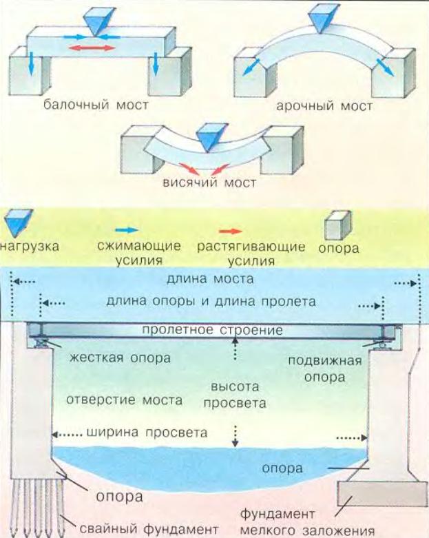
Basics of bridge building. The main forms of bridges are shown at the top, the distribution of forces is marked with arrows. Below are the most important special concepts of bridge construction.
Hanging bridges began to be built later than arched ones. In tropical countries, there are plants with long and strong fibers, such as creepers. Sometimes such plants hang directly over the stream, as if forming natural bridges. That is why people who lived in those parts learned to cross to the other side of a river or gorge with the help of ropes twisted from plant fibers or rawhide, that is, to make suspension bridges. The simplest of them were arranged as follows: two parallel thick ropes, along which travelers moved, and two thinner ones, stretched higher and serving as a kind of railing. Such bridges were thrown, for example, over deep chasms in certain high-mountainous regions of the Himalayas and in the country of the Incas in Peru. Even pack animals with heavy luggage balanced over the abyss on such swinging bridges, the length of which sometimes reached 60 m. In the Himalayas, you can find a more perfect form of a suspension bridge, in which a deck of planks or bamboo trunks is laid on two parallel ropes. But this flooring still sags. But at modern suspension bridges, this flooring is located horizontally, and you can even drive along it. It is suspended on the strongest steel ropes to a thick steel cable, which is supported by high pillars - pylons.
What is an arch bridge?
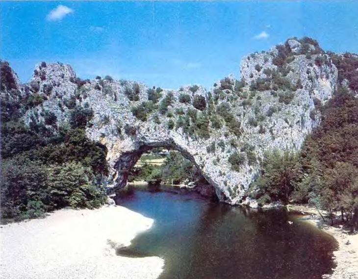
Natural arched bridge 34 m high across the river. Ardèche in the south of France. It was probably once the entrance to a collapsed cave.
An example of a more durable, arched bridge also exists in nature itself - these are openings in the rocks. They are formed in places where the river makes its way under a layer of especially strong rock. The adjacent parts of the rock are gradually destroyed under the influence of water. Such a natural arched bridge rises in the south of France over the Ardèche River, 60 km from the city of Nimes. The width of this rocky arch is 59 m, and the height is 34 m, which is equal to the height of a 10-storey building. Even the Sumerians and Egyptians, about 5000 years ago, erected arched vaults of brick. For a long time, the arch was the only way to create a stone bridge with a relatively long span. This is explained by the fact that stones withstand large pressure forces, or compressive forces, and relatively small tensile forces are destructive for a stone.

The cantilever arch is stable in every phase of construction, the traditional arch - only after the installation of the lock, or key, stone
How these forces are distributed in the beam can be clearly seen on a model made from a thick foam block. On its longitudinal side, you need to draw several vertical lines with a felt-tip pen at the same distance from each other. This bar is placed on top of two stacks of books like a bridge. On top of the middle of this miniature bridge, you need to put another book imitating a load. Now, by observing the lines, you can determine the action of forces in the Styrofoam bar. On the upper side of the bar, the distances between the lines have decreased - the upper layers have compressed, this is the action of a compressive force. But the lower ones, on the contrary, moved apart - there are forces that stretch the foam, this is a tensile force. Tensile forces acting in the lower plane of a loaded stone beam lead to the formation of cracks on it, and then to their expansion, as a result, the bridge may collapse. However, if hewn stones are stacked in layers and in such a way that they form an arch, then they will lean against each other, while being subjected to only compressive, but not tensile forces.
It is believed that the first stone arches were used in the construction of roofs and gate openings. Hewn stones were laid on both sides towards each other so that the upper stone hung somewhat above the lower one, but did not fall. The whole structure remains stable due to the fact that the lower stones are subjected to increasing pressure from the upper ones during laying. In the end, these protruding stones converge, forming an arch. The traditional arch differs from such cantilever structures, built from horizontal layers, in that the joints or seams of its wedge-shaped hewn stones are oriented towards a common center. When building such an arch, you should always use circles - a supporting arc, usually made of boards, less often of metal, along which the arch is laid out. During construction, it takes on the weight of the stones and can only be removed after the installation of a key stone at the highest point of the arch. Only then does the building acquire stability. At the same time, the two lower stones, or the so-called heels, and the arch supports bear the total weight of the entire structure. With this design, each stone is sandwiched between two adjacent ones and cannot, having become loose, simply fall out of the arch.
Why can't you walk across the bridge?
Previously, when planning the construction of a future bridge, builders could rely only on their own experience and intuition. Over the past two hundred years, engineers have been trying, using increasingly sophisticated methods, to pre-calculate the properties of the planned bridge in order to make it more elegant, cheaper and more reliable. These calculations include not only determining the strength of materials and the severity that this bridge can withstand, or the so-called bearing capacity, but also the force with which hurricane winds or water flows act on the bridge.
A great danger also arises if the bridge begins to sway. A simple example: if you carefully walk along a long wooden board fixed only at the ends, it bends, but does not necessarily break. However, if you get into a rhythm that coincides with its own oscillations, then they grow very quickly (resonance effect), and the board may break. There were cases when the bridge collapsed due to the fact that a column of soldiers marched along it in step. This happened because the rhythm of the steps accidentally coincided with the natural vibrations of the bridge. Therefore, before the column entered the bridge, the command was usually given: "Knock down the leg!" The danger of a similar destructive effect exists on railway bridges, which begin to oscillate under the influence of wagon wheels rotating at a certain speed. But today, builders have already learned how to minimize this danger.
Author Aul Huseynov asked a question in Other about cities and countries
why do we need bridges I understand that it's a stupid question but I need a conditional value what is a bridge and got the best answer
Answer from Yoroka[guru]
We drove up to the river, not to change to the boat. Edward briefly said everything
Answer from Alex Sokolov[guru]
"Bridge -
1. An engineering structure thrown over an obstacle (river, ravine, road). Consists of supports and spans. Intermediate supports are called bulls, extreme - abutments.
2. In wooden architecture - the ceiling, the floor of a wooden chopped structure.
(Construction dictionary)
"bridge - BRIDGE, bridge (bridge region), about the bridge, on the bridge, pl. bridges, male.
1. A structure connecting two points on the earth's surface, separated by water, a moat, or some other. an obstacle and enabling communication between them. Bridge across the Volga. Drawbridge. Suspension bridge. Pontoon bridge. Drawbridge. Build a bridge. Cross the bridge to the other side. Railroad bridge.
2. trans. Something connecting, serving as an intermediate link between someone-something (book). Throw a bridge between two warring camps.
3. An elongated position of the body, with the chest up and resting on the floor, on the ground with the palms and heels (in athletics; sports.). Make a bridge.
4. Platform made of boards, logs, etc., flooring (regional and special). Bridge in the hallway of the hut.
5. Part of the chassis of the car, located above the axles (tech.). Rear axle. Front axle.
6. A special bar on which a number of artificial teeth are fixed (special)."
(Explanatory Dictionary of Ushakov)
Answer from Zorina Vera[guru]
Conditional value - connection.
Answer from 3 answers[guru]
Hello! Here is a selection of topics with answers to your question: why do we need bridges, I understand that it’s a stupid question, but you need a conditional value, what is a bridge
