1 and 2 Kamchatka expeditions headed. Kamchatka expeditions (Vitus Bering)
The first Kamchatka expedition of Vitus Bering. 1725-1730.
Vitus Bering was the first Russian navigator to head purposeful geographical expedition. You can read his short biography here. If we draw historical parallels, Bering's expeditions can be compared with the expeditions of James Cook, whose voyages were also the initiative of the Admiralty and the state.
Did the idea of the First Kamchatka Expedition belong to Peter the Great?
Peter was the first of the rulers of Russia to begin a systematic study of the geography of the country, and above all, the instrumental compilation of "general" maps.
The search for Russia's access to the expanses of the world's oceans has always been his "idea fix". But it was not possible to break through to the Black Sea. Dominance in the Baltic was very relative - the Swedes or the Danes at any moment could block the narrow neck of the exit from the Baltic to the Atlantic expanses. Remained Northern sea route and Far East: through the strait between Asia and America, Russian ships could break through to India and China. If there was a strait.
It is known that at the beginning of Peter's independent reign, the first explorer of Kamchatka, Vladimir Atlasov, brought to Moscow a Japanese named Denbey, who was brought by a storm to the southern coast of the peninsula in 1695 and was held captive by the Kamchadals.
Tsar Peter, despite the endless wars in the west, did not forget about the eastern borders of his kingdom. In 1714-1716, at the direction of Peter, sea communication (on boats) was established between Okhotsk and the western coast of Kamchatka. The next step was to find the coast North America, which, as he assumed, is not far from Kamchatka or even merges with Asia. In 1720-1721, one of the expeditions, heading from Kamchatka to the southwest, even reached the middle of the Kuril ridge, but did not find the American coast.
It must be said that the question “whether or not Asia is united with America” was of interest to many in those years. For the first time, the Paris Academy of Sciences, of which Peter was formally a member, turned to Peter I with a question and a request to equip the expedition. The famous German scientist Leibniz had a great influence on Peter I in this matter. Leibniz was not only the initiator of the creation of the Russian (first St. Petersburg) Academy of Sciences, but also advised Peter on many issues state structure and had a great influence on him. But the Dutch East India Company was especially zealous in finding new ways to the East, which at one time brought Peter the Great to power in Russia. For her, the question is "Does Asia connect with America?" was not at all idle. And in 1724, Peter was "finished" before making a decision. And, as you know, Peter had a short distance from making a decision to incarnation.
On December 23, 1724, Peter instructed the Admiralty Board to equip an expedition to Kamchatka under the command of a worthy naval officer. The Admiralty Board proposed to put Captain Bering at the head of the expedition, since he "was in the East Indies and knows how to get around." Peter I agreed with Bering's candidacy. (Dutch too.)
"Tsar's order" of the Bering expedition
On January 6, 1725, (just a few weeks before his death), Peter himself wrote instructions for the First Kamchatka Expedition. Bering and his comrades were prescribed in Kamchatka or in another suitable place build two deck ships
1. It is necessary in Kamchatka or elsewhere to make one or two boats with decks; 2. On these boats near the land that goes to the Nord and by hope (they don’t know the end of it), it seems that land is part of America; 3. For to look for where it met with America: and in order to get to which city of European possessions or if they see which ship is European, to visit from it, as it is called, and take it on a letter and visit the shore themselves and take a genuine statement and, putting it on the map, come here."
The Bering Strait was discovered by Semyon Dezhnev
Some irony of the situation was that the strait between Asia and America was discovered 80 years ago by the Cossack Semyon Dezhnev. But the results of his campaign were not published. And neither Peter, nor the Admiralty College, nor Vitus Bering himself, who was distant in his duties from geographical discoveries. The historian Miller stumbled upon the "tale" about Dezhnev's campaign in Yakutsk, only in 1736, during the Great northern expedition.
Composition of the First Kamchatka Expedition
In addition to Bering, naval officers Aleksey Chirikov and Martyn Shpanberg, surveyors, navigators, and shipwrights were assigned to the expedition. In total, more than 30 people went on a trip from St. Petersburg.
On January 24, 1725, A. Chirikov left St. Petersburg with his team; on February 8, he arrived in Vologda. A week later, Bering joined him with other members of the expedition. The number of full-time members of the expedition alone, both those sent from St. Petersburg and those who joined along the way, reached 20 specialists. In total, under the command of Vitus Bering, including the auxiliary staff (rowers, cooks, etc.), there were about 100 people.
From Vologda to Okhotsk
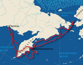
 The expedition covered the distance from Vologda to Tobolsk in 43 days. After a month's rest, we set off again. Almost the entire summer of 1725 the team spent on the road. The winter of 1725-26 was spent in Ilimsk. On June 16, all expedition units arrived in Yakutsk. And only on July 30, 1727, in the third year after departure from St. Petersburg, Bering and his team reached Okhotsk in separate groups. Legend has it that Bering himself, from Yakutsk to Okhotsk, spent 45 days in the saddle! Upon arrival in Okhotsk, without wasting time, they began to build the ship. In total, more than ten thousand miles were covered by water, on horseback, on sleds, on foot ...
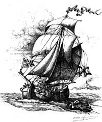
On August 22, 1727, the newly built ship - the galliot "Fortuna" and the small boat accompanying it, which arrived from Kamchatka, left Okhotsk and headed east.
Galiot is a two-masted, shallow-sitting vessel.
From Okhotsk to Nizhnekamchatsk
The journey from Okhotsk to the western coast of Kamchatka took a week, and on August 29, 1727, travelers were already sailing in view of the Kamchatka coast. What happened next is difficult to explain logically. Despite the fact that by that time the Russians had already more or less settled in Kamchatka, Beringa had no idea about the size of the peninsula. There was even an opinion that Kamchatka smoothly passes into Japan, and that there is no through route to the east ... Bering did not even suspect that before southern point There was very little Kamchatka left.
Therefore, the expedition commander decided to land on the western coast and move over the winter to the eastern coast, to Nizhnekamchatsk. There they decided to build a new ship and from there begin the main research. (According to other sources, the hastily built "Fortuna" gave a strong leak, and the expedition was forced to land on the shore). Whatever it was, but Bering went to the mouth of the Bolshaya River and ordered to drag equipment and supplies to the shore.
Bering's journey through the Kamchatka Peninsula
In the Central Archive of the Navy, Bering's reports to the Admiralty - Board on his passage across Kamchatka have been preserved:
“... Upon arrival at the Bolsheretsky mouth, materials and provisions were transported to the Bolsheretsky prison by water in small boats. With this prison of Russian housing there are 14 courtyards. And he sent heavy materials and some of the provisions up the Bystraya River in small boats, which were brought by water to the Upper Kamchadal prison for 120 miles. And in the same winter, from the Bolsheretsky prison, to the Upper and Lower Kamchadal prisons, they were transported quite according to the local custom on dogs. And every evening, on the way for the night, they raked camps out of the snow, and covered them from above, because great blizzards live, which are called blizzards in local language.
The description of the expedition's passage through the Kamchatka Range, the dragging of all property, including materials for building ships, weapons, ammunition, food, took more than two months. On foot, along the rivers and on dog sleds, the expedition covered more than 800 miles! A truly heroic feat.
To the Bering Strait in full sail
 Upon arrival in Nizhnekamchatsk of all cargo and crew members, a new ship was solemnly laid down. It happened on April 4, 1728. Construction proceeded unusually quickly. On June 9, the ship was already completed. And exactly a month later, on July 9, 1728, the well-puttyed and equipped boat "Saint Gabriel" under full sail, with 44 crew members on board, left the mouth of the Kamchatka River and headed northeast.
Only a little more than a month lasted sailing north along the coast of Asia. August 11, 1728 "Saint Gabriel" crossed the strait separating Asia from America. But at that time, the sailors could not know whether this or that was spilled. The next day they noticed that the land, past which they had gone on the same course, was left behind on the left. On August 13, the ship, driven by strong winds, crossed the Arctic Circle.
50 years later, Captain James Cook, during his time, passed through this strait in search of the Northern Sea Route around America. He laid his route from the maps compiled by Vitus Bering.
Struck by the accuracy of the Russian pilots, James Cook suggested that the strait between the continents be named after Bering. So, at the suggestion of this great navigator, one of the most significant straits on earth received the name of our no less great compatriot.Bering's expedition completed its task
 On August 15, the expedition entered the open (Arctic) Ocean and continued sailing to the north-northeast in complete fog. Lots of whales appeared. The boundless ocean spread all around. The Chukotka land no longer extended further north. No other land was visible.
At this point, Bering decided that the expedition had completed its task. He did not find any American coast in the line of sight. There was no isthmus further north. Having gone a little further north to clear his conscience, to latitude 67 "18", on August 16, 1728, Bering gave the order to return to Kamchatka so that "for no reason" he would not spend the winter on unfamiliar treeless shores. Already on September 2, 1728, "Saint Gabriel" returned to the Nizhnekamchatka harbor. Here the expedition decided to spend the winter.
Bering understood that he had completed only part of the task. He didn't find America. Therefore, in the summer of next year, he and his associates made another attempt to break through to the American shores from the east. Putting to sea in June 1729, the expedition traveled due east for 200 miles and did not meet any signs of land.
Nothing to do but turn back. But on the way to Okhotsk they bypassed Kamchatka from the south and established the exact southern tip of the peninsula. This discovery became extremely important and necessary for all subsequent expeditions. Oh, if only they themselves knew the true size of Kamchatka, they wouldn't have to drag the whole load over hundreds of miles on dry land!
Vitus Bering. short biography. What did you discover?
Russian travelers and pioneers
Again
Travelers of the Age of DiscoveryThe plan of the expedition was as follows: through Siberia by land and along the rivers to Okhotsk, from here by sea to Kamchatka and then sailing on ships in search of the strait.
On January 24, 1725, the expedition members left St. Petersburg. In order to notify the Siberian governor of the expedition and oblige him to provide assistance, on January 30, 1725, a decree of the empress was sent to Siberia, which contained some unclear points. For this reason, at the request of Bering, in early February of the same 1725, a second decree was sent, which listed all the types of assistance needed by the expedition. In January 1727 the expedition reached Okhotsk. Even before Bering arrived in Okhotsk, a ship was built here for the expedition in 1725, which was launched in June 1727 and named Fortuna. On this ship, the expedition members, along with all the equipment on September 4, 1727, moved from Okhotsk to Bolsheretsk, located at the mouth of the river. Large on the western coast of Kamchatka. The sea route from Okhotsk to Kamchatka was discovered by the expedition of K. Sokolov and N. Treska in 1717, but the sea route from the Sea of Okhotsk to the Pacific Ocean had not yet been opened. Therefore, sailing around Kamchatka through the First Kuril Strait, which was not explored, was dangerous. Cross the peninsula along the rivers Bolshaya, its tributary Bystraya and along the river. Kamchatka also failed: Spanberg, sent with property on 30 ships, was overtaken by frost.
On January 24, 1725, Bering's companion Chirikov left Petersburg with his team. On February 8, he arrived in Vologda, where a week later Bering joined him with other members of the expedition. The number of all ranks, participants in the expedition, both sent from St. Petersburg and joined in Tobolsk Okhotsk, extended to 20, and in total there were about 100 people under Bering's command. except for the aforementioned Lieutenant Alexei Chirikov, midshipman, later midshipman Pyotr Chaplin and Lieutenant Martyn Shpanberg. - The expedition, called the first Kamchatka expedition, covered the distance from Vologda to Tobolsk in 43 days. After a month's rest, she continued her journey along the Irtysh on 11 boardwalks. On May 23, Chaplin with a detachment of 10 people was sent forward towards Yakutsk. The team spent almost the entire summer of 25 years on the road. Having wintered in Ilimsk, from where Shpanberg was sent, with a detachment of 39 people, to Ust Kutsyu prison, on the Yenisei, to build 15 barges, on May 26, 1726, Bering sailed down the Yenisei on new ships. On July 16, Bering arrived in Yakutsk, and only on July 30, 1727, in the third year after leaving St. Petersburg, did he finally arrive in Okhotsk, from where the real journey was to begin. Having stocked up here with provisions and new ships, the expedition left Okhotsk on August 22 and arrived by sea two weeks later in Bolsheretsk (in Kamchatka). From here she went by land to Nizhne-Kamchatsk, where she arrived on March 11, 1728, having used about 2 months for the whole journey (883 versts). Having loaded a boat in Nizhne-Kamchatsk with provisions - "St. Gabriel", built in the same place, Bering with his entire expedition sat on it and on July 13, 1728 left the mouth of the river. Kamchatka in the sea, keeping to the northern direction between Asia and America. Immediately after anchoring, the ship's commander and his navigators began an inventory of the coasts along which they passed, recording the results of navigational and astronomical observations in the log book with an accuracy of a hundredth of a minute, and the results of taking bearings on coastal objects (capes, mountains, etc.) d) to the nearest minute. On the basis of navigational and astronomical determinations, a map of Northeast Asia and the adjacent islands was drawn up. stretches to the west and that therefore "it is impossible for Asia to connect with America," he considered his mission accomplished and, with the consent of all the members of the expedition, who were afraid of "inadvertently falling into the ice," turned back. All observations were carefully recorded in the logbook. During the voyage to the Bering Strait (1728) and then along the coast of Kamchatka (1729), the ship's commander and his navigators described the coast, making geographical discoveries every day. The inventory was made systematically, carefully and conscientiously. On some days, sailors took bearings of up to 8 landmarks. The records of bearings for the sighted coastal objects in the logbook are so detailed that they make it possible to restore with sufficient accuracy what geographical discoveries were made. Most of these discoveries remained unknown, as did records of the St. Gabriel's voyage across the strait between Asia and America.
Geographical discoveries and research are always accompanied by mapping, so the map is one of the main sources of the history of discoveries. The materials relating to the First Kamchatka Expedition mention three maps presented by Bering.
We learn about the first of them from the minutes of the Conference of the Academy of Sciences dated January 17, 1727, which refers to the consideration of J. N. Delisle "Captain Bering's map about Russia". The second map, compiled by V. Bering and P. Chaplin, depicting the route from Tobolsk to Okhotsk, was sent from Okhotsk in June 1727. The third (final) map of the expedition was attached to Bering's report.
We became aware of the fourth map only in 1971. Based on the results of the expedition, the original map of V. Bering and P. Chaplin was discovered by A. I. Alekseev in 1969 in the Central State Archive of Ancient Acts, later it was published by A. V. Efimov. This map shows the results of the First Kamchatka Expedition. The map of V. Bering and P. Chaplin in 1729 provided the most valuable information about the northeastern tip of Siberia and formed the basis of cartographic works, starting with the atlas of I.K. Kirillov, and had a huge impact on world cartography. The final map of the First Kamchatka Expedition became known to researchers soon after the end of the expedition. This document proves that during the First Kamchatka expedition, for the first time, the coast of northeast Asia from the mouth of the river was completely correctly mapped. Hunting to Cape Kekurny (Chukotsky Peninsula). It is enough to compare the map of I. Goman in 1725, reflecting the achievements of geographical science by the beginning of the First Kamchatka expedition, with the map of V. Bering and P. Chaplin in 1729 [Fig. 3] to make sure that Northeast Asia was first explored and mapped by Bering and his assistants.
The final map of the First Kamchatka expedition was widely used in Russia and abroad and was used in the preparation of maps by J. N. Delisle (1731, 1733, 1750, 1752), I. K. Kirillov (1733-1734), Zh. Dugald (1735), J. B. D "Anville (1737, 1753), I. Gazius (1743), authors of the Academic Atlas (1745), A. I. Chirikovsh (1746) , G. F. Miller (1754-1758) The first historical navigation charts "St. Gabriel", compiled by A. I. Nagaev and V. N. Verkh.
The coastline of the northeastern part of the Asian continent on the Final Map of the First Kamchatka Expedition and on modern maps is largely similar. The map shows the discoveries made by Bering during the 1728 voyage: the Ozernoy, Ilpinsky, Olyutorsky peninsulas, capes Nizky, Kamchatsky, Opukinsky, etc. The Gulf of Anadyr with its entrance capes Navarin and Chukotsky is well shown. In this bay, the ship's commander and his navigator correctly marked the hall. Cross, m. Thaddeus, buch. Gabriel, m. Sheer, bukh. Transfigurations, etc. The outlines of the Asian shores to the north of the Gulf of Anadyr are also fairly accurate on the map: capes Chukotsky, Kygynin, Chaplin, bay. Tkachen and others.
The Final Map shows that the Chukotka Peninsula (its extreme eastern point - Cape Dezhnev) is not connected to any land; in the Bering Strait, Diomede Islands are plotted, about. St. Lawrence. The huge archipelagos that we see on Academic maps are not on this map; three northern Kuril Islands, southeast and south- West Coast Kamchatka.
An important source of materials on the results of the voyages is the General Chart of the Naval Academy of 1746, which has become well known only in recent decades. On the map of the Maritime Academy, the northeastern coast of Asia from the mouth of the river. Hunting to Cape Kekurny is based on the Final Map [Fig. 1,2,3] of the First Kamchatka Expedition and, on the whole, the achievements of the First and Second Kamchatka Expeditions are summed up quite correctly.
On September 2, 1728, Bering was already at the mouth of Kamchatka, where he wintered, and on June 5 of the following year he went by sea to the east, but, having not met land at a 200-verst (according to his calculation) distance from the coast of Kamchatka, he turned back, rounded the m Lopatka and on July 3 went to Bolsheretsk. After 20 days was already at the mouth of the river. Hunt, from where he went on his way back to St. Petersburg, where he arrived on March 1, 1730. Here he presented his journal, maps and two proposals to the government, in which, among other things, he expressed a desire to equip a new expedition to explore the sowing. and sowing east coast of Siberia.
The Admiralty Board, which examined his journal and maps, although they did not quite trust Bering's discovery, nevertheless, due to the "difficulties of the expedition," requested him the rank of captain and a cash reward of 1000 rubles. The Senate and Admiral were approved. board and Bering's "proposals", and this approval was followed (December 28, 1732) and the highest permission to appoint a new expedition, known as the second Kamchatka expedition.
While England, France and Holland shared the colonial legacy of Spain and Portugal, a new world power was rapidly rising in the east of Europe. Having victoriously ended the war with Turkey, Russia, under the leadership of Peter I, reached the shores of the Sea of Azov. To establish direct ties with the West, it remained to return the Russian lands occupied by Sweden, and thus break through to the Baltic. The Northern War, which lasted more than 20 years, ended in complete victory: under the Treaty of Nystadt in 1721, Russia received lands in Karelia and the Baltic states with the cities of Narva, Revel, Riga and Vyborg. And immediately after that, as a result of the Persian campaign, the western coast of the Caspian Sea with Derbent and Baku was conquered. Russia strengthened its positions in the west and south. What happened in the east?
Kamchatka is the most distant Russian territory. Chukotka, of course, is to the east, but in order to get to Kamchatka by land, and not by water or air, you must first go through Chukotka. Therefore, Kamchatka was discovered later than the rest of the mainland territories of Russia. For a long time, this achievement was attributed to the Cossack Pentecostal Vladimir Vasilyevich Atlasov, who in 1697 came here from Anadyr at the head of a large detachment. Atlasov overlaid yasak on the local population, built two prisons, and on the bank of one of the tributaries of the Kamchatka River he installed a large cross, a symbol of the annexation of a new land to Russia. However, Atlasov, whom A. S. Pushkin called "Kamchatka Yermak", went to the peninsula in the footsteps of Luka Staritsyn (Morozko), who had been there several years earlier.

There is evidence of Russian explorers staying in Kamchatka even in more remote times. According to some historians, almost 40 years before Atlasov, Fyodor Chukichev and Ivan Kamchatoy passed a significant part of the peninsula; in honor of the latter, the largest local river was named, and only then the peninsula itself. Kamchatka researcher S.P. Krasheninnikov claimed that even earlier, in 1648, a storm had thrown Fedot Popov and Gerasim Ankidinov, Semyon Dezhnev's companions, here.
But it was after Atlasov's campaign that the annexation of Kamchatka to Russia began. Moreover, thanks to him, it became known in Moscow that some kind of large land lies to the east of Chukotka. Neither Atlasov nor the others saw her, but in winter, when the sea froze, foreigners came from there, bringing "sable" (in fact, it was an American raccoon). Simultaneously with the news about the land east of Chukotka, Atlasov brought to Moscow information about Japan, and at the same time the Japanese Denbey, captured by the Russians in Kamchatka.
In the reign of Peter I, Russian science stepped forward by leaps and bounds. The need for its development was dictated by practical needs, economic and military. So, by order of Peter I, the beginning of the geographical study of the country and mapping was laid. A large detachment of travelers and geodesists trained at the Navigation School and the Naval Academy began to study the vast country. In 1719, on behalf of the Tsar, Ivan Evreinov and Fyodor Luzhin surveyed Kamchatka and the Kuril Islands and compiled their maps.
Peter I attached paramount importance to the study of trade routes, in particular to India and China. In this sense, Atlasov's information about Japan was of undoubted interest. However, the king was even more interested in information about the mysterious big land near Chukotka. Peter I corresponded with many scientists, including Gottfried Wilhelm Leibniz. The latter was extremely interested in the question: are America and Asia separated or do they converge somewhere? And the place where two continents can meet is just east of Chukotka. Leibniz repeatedly wrote about this to Peter I. Note that Dezhnev's discovery went unnoticed for a long time - even in Russia.
Sending Evreinov and Luzhin to Kamchatka, Peter I gave them the task of determining the location of America. By understandable reasons surveyors were unable to solve this problem. In December 1724, shortly before his death, the emperor wrote instructions for the First Kamchatka Expedition, which was to find out whether Asia was connected to America in the north. To do this, it was necessary to get to Kamchatka, build one, or better two deck boats there and go to them in a northerly direction. Having found America, the expedition had to move south along its coast - to the first city founded by Europeans, or to the first oncoming European ship. Everything had to be mapped. open lands, straits and settlements, collect information about the peoples who inhabited the northeast of Russia and the northwest of America, and, if possible, begin trade with America and Japan.
Peter appointed Vitus Bering, a Dane, who had been in the Russian service for more than 20 years, as the head of the expedition. Vitus Jonassen Bering, born in 1681 in Horsens, was trained in the marine cadet corps in Holland, sailed in the Baltic and Atlantic, visited the East Indies. Being invited to Russia by Peter I, he participated in the Russian-Turkish and Northern wars. Bering's assistants were Martin (Martyn Petrovich) Shpanberg, also a native of Denmark, and a graduate of the Naval Academy Alexei Ilyich Chirikov.
The expedition was equipped immediately, but ... First, several groups traveled to Vologda, then more than a month to Tobolsk. Several detachments again went through Siberia - sometimes on horseback, sometimes on foot, but mostly along the rivers. In the summer of 1726 we reached Yakutsk. From here it was necessary to go more than 1000 km to Okhotsk - through the mountains, through the swamps, and even with tools, sails, anchors for ships that were planned to be built for sea voyage. The horses could not endure the hardships of the journey, and every single one fell. Now the loads were carried on boards up the Maya and Yudoma, and when winter came, on sleds.
Only in January 1727 did the expedition reach Okhotsk. Even earlier, Bering's group arrived there, moving light. Here, travelers were already waiting for the Shitik (a boat with sewn sides) “Fortune”. In September, the expedition members, along with all the equipment, moved on the "Fortune" to the western coast of Kamchatka, to Bolsheretsk, then by dog sled - to the eastern coast. In March 1728 the expedition arrived in Nizhnekamchatsk.
The boat "St. Gabriel" was built here, which in July 1728 went north. From the first day of navigation, the navigators wrote down the results of navigational and astronomical observations, took bearings of mountains, capes and other coastal objects. Based on all these measurements, maps were drawn up. On the way to the north, the expedition discovered the bays of Karaginsky, Anadyrsky, Providence Bay and Cross Bay, St. Lawrence Island.
August 16 "Saint Gabriel" reached 67 ° N. sh. A day earlier, in the west, the sailors saw mountains - apparently, it was Cape Dezhnev. Thus, the Bering expedition for the first time after Dezhnev passed through the strait between Asia and America, this time from the south. Travelers did not see the opposite, American coast: the distance between the continents at the narrowest point of the strait is 86 km. Since there was open sea ahead, and the Asian coast went west, Bering decided that the existence of the strait could be considered proven, and turned back. Only Chirikov offered to continue sailing in a westerly direction, to the mouth of the Kolyma, in order to finally verify the validity of this assumption. But Bering and Spanberg, foreseeing worsening weather conditions, insisted on returning. On the way back one of the Diomede Islands was discovered. Already in early September, "Saint Gabriel" reached the mouth of Kamchatka, where the travelers wintered. In June of the following year, Bering put to sea and headed straight east. So he thought to reach America. After passing about 200 km in dense fog and not meeting land, he turned back, rounded Kamchatka and arrived in Okhotsk. In two years, Bering with satellites surveyed more than 3,500 km of the coast.
In early March 1730, the expedition members returned to St. Petersburg. In the capital, Bering presented the materials of the voyage to the Admiralty Board - a magazine and maps. The final map of the expedition was widely used in Russia and abroad. Although it contains many errors (the outlines of Chukotka are distorted, the Gulf of Anadyr is too small, etc.), it is much more accurate and detailed than all the previous ones: it contains the islands of St. Lawrence and Diomede, the Kuril Islands, the coast of Kamchatka, and most importantly, the Chukotka Peninsula east is washed by water. As a result, this map became the basis for later maps by J. N. Delil, I. K. Kirilov, G. F. Miller, as well as the Academic Atlas (1745). James Cook, half a century later, following Bering's route along the coast of northeast Asia, noted the accuracy of the cartographic work carried out by the expedition.
However, her main goal - the American coast - was not achieved. Moreover, the Admiralty considered that the evidence presented by Bering for the absence of a land connection between the two continents was unconvincing. At the same time, he received the highest permission to lead a new expedition to the Pacific Ocean. By the way, in 1732, navigator Ivan Fedorov and surveyor Mikhail Gvozdev on the "St. Gabriel" again passed through the strait and made a map of it. Unlike Bering, they approached American soil - Cape Prince of Wales.
The sea in the North Pacific Ocean and the strait between Asia and America, at the suggestion of James Cook, were named after Bering, because Dezhnev's notes had been collecting dust in the Yakut archive for a long time. Maybe this is a kind of justice: Dezhnev discovered, but did not know what, and Bering did not discover, but he knew what he was looking for.
NUMBERS AND FACTS
Main character
Vitus Jonassen Behring, a Dane in Russian service
Other actors
Peter I, Russian emperor; Martin Spanberg and Alexei Chirikov, Bering's assistants; Ivan Fedorov, navigator; Mikhail Gvozdev, geodesist
Time of action
Route
Through all Russia to Okhotsk, by sea to Kamchatka, from there to the north, to the strait between Asia and America
Target
Find out if Asia and America connect, reach American shores
Meaning
Second passage of the Bering Strait, numerous discoveries, mapping of the coast of northeast Asia
Domestic navigators - explorers of the seas and oceans Zubov Nikolai Nikolaevich
2. First Kamchatka expedition (1725–1730)
2. First Kamchatka expedition
Peter the Great did not forget the Far Eastern outskirts of Russia, about which more and more information was received in his time.
It is quite certain that Kamchatka was first visited in 1696. service man Morozko (Staritsyn). The first, and extremely complete, geographical description Kamchatka was made by Vladimir Atlasov, who made a remarkable journey along the whole of Kamchatka, almost to Cape Lopatka (1697–1699). At the same time, Atlasov “saw as if there was an island” (Kuril Islands.-N. 3.).
In 1700, Ivan Shamaev reported that “opposite the Karaga River in the sea there is an island, and on that island Ivan Golygin and his comrades, three people in canoes went to visit foreigners, and rowing to that island in canoes for a day ... And after it , Ivan, Russian people have never been on that island ... "
Based on this report, D. M. Lebedev believes that the Karaginsky Island was not only known, but also visited by Russians no later than 1700–1701.
In 1702, the navigator Mikhail Nasedkin was sent to Kamchatka.
In his message, Nasedkin, among other things, said that “there is an island opposite the Kamchatka mouth, and what kind of people there are on that island, that he, Mikhailo, does not know ...”
Based on this report, D. M. Lebedev believes that the Russians received the first, albeit vague, information about the Commander Islands as early as 1700, and these rumors reached Yakutsk no later than 1710.
In addition to information about Kamchatka, Nasedkin, no later than 1706, quite definitely spoke about the Kuril Islands, which he saw from Cape Lopatka: “there is land in the sea beyond the overflows, and there is nothing to visit the children of that land.”
The fact that in the Far East at that time they knew about the existence of the Bering Strait is evidenced by the testimony of Atlasov, given by him in Moscow in 1701, namely: “between the Kolyma and Anadyr rivers there is a necessary bow that fell into the sea, and on the left side that nose (i.e., in the Chukchi Sea. - N. 3.) there are ice on the sea in summer, and in winter that sea is frozen, and on the other side of this bow (i.e., in the Bering Sea. - N. 3. ) there is ice in spring, but not in summer. And he, Volodymyr, had never been on this necessary nose. And the local foreigners of the Chukchi, who live near that nose and at the mouth of the Anadyr River, said that there is an island opposite that necessary nose, and from that island in winter, when the sea freezes, foreigners come ... "
It cannot be emphasized that Atlasov had knowledge not only about the geography of Cape Dezhnev, but also about the ice regime of the Chukchi and Bering Seas.
There were other information as well.
In 1711, the Yakut Cossack Pyotr Ilyich Popov and the industrialist Yegor Vasilyevich Toldin went to the Anadyr Nose (Cape Dezhnev.-N. 3.) and learned that there was a strait between Asia and America, that there were islands in this strait, on which live "toothed people" and that the Russians used to pass this strait on the cochs.
In 1711, Danila Yakovlevich Antsyferov and Ivan Petrovich Kozyrevsky moved to the northern Kuril Islands (Shumsha and Paramushir (?). In 1713, Kozyrevsky, at the head of a detachment of Cossacks, again visited the first three Kuril Islands and compiled them schematic maps and descriptions. In addition, he collected information about Japan and sea routes to it. In 1713, Cossacks Semyon Anabara and Ivan Bykov visited the Shantar Islands in the Sea of Okhotsk.
Travel to Kamchatka was made at that time only by land. Peter promised a big reward for opening a sea route to it.
In 1716, the Cossack Pentecostal Kuzma Sokolov and the sailors Yakov Vlasov Neveitsyn and Nikifor Moiseev Treska on the 54-foot-long boat “Hunting” built in Okhotsk, sailed to Kamchatka, spent the winter on it and returned to Okhotsk. Sokolov made a map of his voyage.
Up to this time, the charts made by navigators were by eye and therefore very inaccurate. In 1719, Peter sent two surveyors to the Far East - Ivan Mikhailovich Evreinov and Fyodor Fedorovich Luzhin, who had been released ahead of schedule from the Naval Academy founded in 1715 in St. Petersburg. Evreinov was sent “... to Kamchatka and beyond, where you are indicated, and describe the local places where America and Asia converged, which must be carefully done, not only south and north, but also east and west, and put everything on the map properly” .
A. V. Efimov notes that Evreinov and Luzhin were assigned other tasks, namely: an inventory of the Kuril Islands and the collection of information about Japan.
In the autumn of 1720, on a boat built in Okhotsk, Evreinov and Luzhin arrived in Kamchatka, where they spent the winter, and in 1721 set off from Kamchatka to the southwest and described fourteen Kuril Islands up to and including Simushir Island. A report on the voyage, maps of Siberia, Kamchatka and the Kuril Islands Evreinov presented to Peter in 1722.
The results of the work of Evreinov and Luzhin did not satisfy Peter. He dreamed of finding maritime trade routes to China, Japan and India. The Northern Sea Route was the shortest and completely passed through domestic waters.
In vain did some historians further strive to show that Peter's interest in the North was awakened by the letters of the famous philosopher and mathematician Leibniz or the requests of the Paris Academy of Sciences. The Russian people own both the very idea of the Northern Sea Route and the projects for its practical development. The state benefit of this path was recognized by the closest associates of Peter. Back in 1713, one of the most educated people of that time, Fyodor Stepanovich Saltykov, presented to Peter his famous “prepositions” on the measures necessary for the development of the northern outskirts of Russia.
A year and a half later, Saltykov presented more detailed considerations, in which there was a special chapter "On finding a free sea route from the Dvina River even to the Omur Estuary and to China."
It should be noted that in his second preposition, “Statements Profitable to the State”, sent to Peter on August 1, 1714, Saltykov proposed to explore the Northern Sea Route “to build ships in the lower reaches of the Northern Dvina, the Ob, on the Lena near Yakutsk, near Svyatoy Nos, and also on the Amur Estuary, if only this river is subject to Russia.
Further, Saltykov advised “to describe along the other bank from the course of the sea, from the Dvina mouth to the Ob mouth, and from the Ob to the Yenisei, and from the Yenisei to the Lena and to the last river mouth, which is searched conveniently near the Amur river, and along the mouth of the Amur and along between Yepon and Chinas" and wrote detailed instructions for every kind scientific research. As we will see later, many of Saltykov's proposals were included in the work plan of the Great Northern Expedition. The explorer of the Caspian Sea F. I. Soimonov reported to Peter the Great about the need to study the Northern Sea Route.
The study of the Northern Sea Route was really necessary. Much of what was done by Russian sailors in the 17th century was very inaccurate, and much has been forgotten. Suffice it to recall that the reports of Semyon Dezhnev were discovered in the Yakut archive only 90 years after his great geographical discovery.
However, Peter failed to carry out his plans. Three weeks before his death, in January 1725, Peter said to Admiral General Fyodor Matveyevich Apraksin: “Poor health (mine) made me sit at home; I remembered the other day what I had been thinking about for a long time and that other things prevented me from doing it, that is, about the road through the Arctic Sea to China and India. On this chart of the sea, the path laid out, called Anian, is not laid out in vain. During my last journey, in conversations, I heard from learned people that such an acquisition is possible. Protecting the fatherland with security from the enemy, one should try to find the glory of the state through art and science. Shall we not be happier in exploring such a path than the Dutch and the British, who have repeatedly attempted to search the American shores?
These words of Peter, like many of his other testaments, were long remembered by his successors. A. S. Pushkin wrote: “The insignificant heirs of the northern giant, amazed by the brilliance of his greatness, imitated him with superstitious accuracy in everything that did not require new inspiration.”
In fulfillment of his plan, Peter personally wrote the instructions for the proposed expedition at the same time. This instruction said:
"one. It is necessary in Kamchatka, or in another place there, to make one or two boats with decks.
2. On these boats (sail.-N. 3.) near the land that goes to the north, and by hope (they don’t know the end of it) it seems that that land is part of America.
3. And in order to look for where it met with America, and in order to get to which city of European possessions, or if they see a European ship, visit from it, as this kust (shore) is called, and take it on a letter and visit the shore themselves , and take a genuine statement and put it on the map, come here.
Peter himself appointed the leaders of the expedition: a Dane in the Russian service, Captain 1st Rank Ivan Ivanovich (Vitus Jonssen) Bering, a Dane, Lieutenant of the Russian Service Martyn Petrovich Shpanberg, and a pupil of the Naval Academy, Lieutenant Alexei Ilyich Chirikov. The midshipman (later midshipman) Pyotr Avraamovich Chaplin also took part in the expedition.
Peter was distinguished by his ability to choose people, but this time he was wrong. Bering was an excellent and diligent naval officer, but as the head of a large enterprise he was not up to par - he was lost, getting into unusual conditions, and was afraid in difficult moments to take responsibility.
The last party of the expedition left Petersburg on February 5, 1725 and arrived in Yakutsk in early June 1726.
Most of the provisions and light cargo were sent from Yakutsk in packs by horses. With great difficulty, having lost more than half of the horses (out of 600) on the way, this party reached Okhotsk in October. More heavy loads- guns, anchors, sails, part of the provisions - were sent on fifteen ships built in Yakutsk along the Lena, Aldan, May and Yudoma rivers to the Yudoma cross. They expected to deliver these goods by dry route to Okhotsk, or drag them through the portage to the Urak River, which flows into the Sea of Okhotsk near Okhotsk. Then they were going to transfer the cargo by sea to Okhotsk. However, this detachment under the command of Spanberg was caught on the way in winter and only reached a point slightly above the mouth of the Yudoma. Spanberg, an extremely active man, but also extremely cruel, in order not to waste time, decided to transport heavy loads, "in the winter way on sleds, harnessing them with people."
The frosts were severe, the team was exhausted to the extreme, all the provisions came out, they ate “belts, shoes, carrion and their dogs ... Many died, including ... navigator Morison and surveyor Luzhin; others ran off the road to Yakutsk.” Part of the cargo had to be left on the way; they were delivered to Okhotsk only in the middle of the summer of 1727.
At that time, in Okhotsk, specially sent from Yakutsk in 1725, artisans completed the construction of a shitik called "Fortuna". In addition, there was a lodia in Okhotsk, on which the first voyage across the Sea of Okhotsk was made in 1716, but this ship was in poor condition. Another lodia, built in 1720, was soon to return to Okhotsk from Kamchatka.
Map of Ivan Lvov, brought to St. Petersburg in 1726 by A. F. Shestakov (many names and inscriptions omitted).
On July 1, 1727, Shpanberg on the "Fortune" with part of the expedition's cargo, which was later supposed to be transferred by land to Nizhne-Kamchatsk, went to Bolsheretsk and returned very quickly on August 11. On June 10, the Lodia of 1720 returned to Okhotsk and it was immediately repaired.
On August 21, the Fortuna Shitik, on board of which were Bering and Shpanberg, and the Lodia of 1720, commanded by Chirikov, went to sea and arrived in Bolsheretsk on September 4.
With great difficulty, people with loads on philistine dogs moved to Nizhne-Kamchatsk. Here, in April 1728, a boat was laid down and launched on June 8 (60 feet long, 20 feet wide, with a draft of 7? feet), called “St. Gabriel." On June 6, Kondratam Moshkov, a navigator from the Arkhangelsk Pomors, brought from Bolsheretsk to Nizhne-Kamchatsk the “Fortune” shitik. It was supposed to take the shitik with you, but it required major repairs and, in order not to lose precious navigational time, this had to be abandoned. The Lodia of 1720 was sent from Bolsheretsk to Okhotsk.
Staying in Nizhne-Kamchatsk was difficult. Provisions were in short supply, they had to buy deer, fish with nets made from nettles, make wine from the local sweet grass, evaporate salt from sea water.
A. Polonsky emphasizes that, while in St. Petersburg, Bering might not have known about the strait between America and Asia. The capital learned about this only after the discovery by Academician Miller in 1736 during the Second Kamchatka Expedition of Dezhnev's original documents. But in Siberia, both the authorities and local residents remembered this well. So, back in Yeniseisk, Bering wrote:
“If it was determined to go from the mouth of the Kolyma to Anadyr, where it is possible to pass in every possible way, what new Asian maps testify, and the inhabitants say that before this, walked this way, that could have been done with a smaller cost.”
Finally, in Siberia, it was known that “the navigator Procopius Nagibin, having learned in Anadyrsk about the proximity of America to Cape Anadyr (as Cape Dezhnev was sometimes called in those days.-N. 3.), Back in 1720, he asked to give him 200 people for research teams and yarn for nets for the manufacture of fish for marine provisions, which was not respected ... ". Nagibin, not having received the requested funds, built a ship for an expedition to America at his own expense. But in 1725, the Chukchi attacked this ship on the Anadyr River and Nagibin was killed.
Undoubtedly, during his long stay in Yakutsk, Okhotsk and Nizhne-Kamchatsk, Bering could collect a lot of information about the areas of the upcoming voyage, in particular that Asia is not connected with America. Naturally, Bering should have at least supplemented the information already available, but, as we will see later, he did not.
Finally, on July 13, 1728, almost three and a half years after leaving Petersburg, Bering on St. Gabriel" went to sea. On the way to the north, he entered the Gulf of Anadyr, on August 1 he visited the bay of the Holy Cross, and on August 6 he entered the bay of Transfiguration, in which he stocked up on water.

Swimming Bering and Chirikov on "St. Gabriel" (1728 and 1729) (according to V. Berkh, the map is simplified, many names have been removed).
Thus, Bering received from the Chukchi a new confirmation of the existence of a strait between Asia and America.
On August 9-11, during a detour of the Chukchi Nose, we saw the island of St. Lawrence, about which the Chukchi told Bering and which, as we will see later, had already been shown on the map of Lvov in 1726.
August 13 at 65°30? With. sh. Bering convened a meeting of officers on the further voyage. Spanberg proposed to go north until August 16 and, if an isthmus between Asia and America is not found, then at 66 ° N. sh. turn back.
A. I. Chirikov, on the contrary, suggested:
“Before, there is no news up to which degree of width from the North Sea, near the eastern coast of Asia, from known peoples, European residents have been; and therefore we cannot reliably know about the separation of Asia and America by the sea, if we do not reach the mouth of the Kolyma River, or to the ice - it is known that ice always moves in the North Sea - for this we must certainly, by the power of the decree given to your nobility, go near the land, if the ice does not interfere, or the coast does not move to the west, to the mouth of the Kolyma River, to the places shown in the indicated e.i.v. decree, and if the land still leans to N, then it is necessary, on the twenty-fifth day of this present month, to look for places in these places where it would be possible to spend the winter, and especially against the Chukchi nose, on the land on which, according to the tale received from Chukchee, through Peter Tatarinov, there is a forest. And if there are opposite winds before the indicated date, then always look for a winter harbor at that time. In this proposal, the modest Chirikov showed himself to be an intelligent and courageous sailor.
August 15, 1728 at 67°18? With. sh., i.e. already in the Chukchi Sea, Bering decided to turn south due to fear of wintering. It is appropriate here once again to recall the instructions of Peter the Great, in which surveyors Luzhin and Evreinov were ordered to find out whether America agreed with Asia, which should be very carefully done, not only south and north, but also east and west ... "But Bering limited himself to swimming only on "north and south".
On August 17, on the way back, an island was seen, named after the saint of that day, the island of St. Diomede, also already shown on the map of Lviv in 1726.
The following year, 1729, Bering, having sent "Fortune" to Bolsheretsk, to "St. Gabriel went east to search for land, which, according to the stories of local residents, in clear weather can be seen from the shores of Kamchatka. Having traveled about 200 miles and not seeing any land, Bering turned back, and, having rounded Kamchatka, on July 23 he arrived in Okhotsk. In 1730 Bering returned to St. Petersburg.
Thus ended Bering's First Kamchatka Expedition, which had cost enormous amounts of money. Counting from leaving St. Petersburg to returning back, she lasted about five years, and during this time she worked at sea for only about three months.
It is curious that in 1728, as A. V. Efimov emphasizes, “two expeditions went to America - Bering and Melnikov, and not just Bering’s expedition, as is commonly thought.”
Afanasy Melnikov in 1728, apparently on a Shitik, went to the Bering Strait to describe the islands and the route to the Great American Land. On the way, his ship was broken by ice, and with difficulty, only in 1729, he reached Anadyrsk. In 1729 Melnikov made another unsuccessful attempt. Finally, in 1730, Melnikov reached Cape Dezhnev. Here he met two "toothed" Chukchi (the inhabitants of Diomede Island were called toothed Chukchi, according to their custom of inserting pieces of bone into the slots in their lips), who told him that it was possible to reach America along the Bering Strait by canoes in two days. However, the Chukchi refused to transfer him to America.
Melnikov's perseverance especially wins in comparison with Bering's indecisiveness. Involuntarily, perplexed questions arise: Why didn't Bering go east in the Chukchi Sea, at least to the ice edge? Why didn't Bering, seeing one of the Diomede Islands, try to explore it? Why did Bering go back to Kamchatka in an almost direct course and, thus, did not use the opportunity to explore areas unknown at that time? Why in 1729 did he not repeat the voyage to the Bering Strait and so hesitantly searched east of the mouth of Kamchatka for the land that the locals had told him about? Indeed, from Cape Kamchatsky to the northwestern cape of Bering Island, on which he was destined to die in thirteen years, only about 180 kilometers. And the discovery of the Commander Islands in 1729 could radically change subsequent events.
Lomonosov also wrote: “It is a pity that, going back (Bering.-N. 3.), He followed the same road and did not move further to the east, which, of course, could have marked the shores of North-West America.”
Upon his return to St. Petersburg, Bering presented a map of the voyage and a brief report. This report was first published in 1735 in the work of the French Jesuit du Alda "Description ... of China and Chinese Tartary." It was published in Russian only in 1847.
From the book of Paul I author Peskov Alexey Mikhailovich1725 On January 28, 1725, Peter the Great died. The formidable voice fell silent, the terrible look closed. He died, leaving his all-pervading name to his faithful subjects, but without bequeathing any orders about the heir to the throne, except for the decree of 1722, which decreed “so that this is always in the will
From the book Nikolai Vavilov author Reznik Semyon Efimovich1730 But - the most important word in the story of the events of life, because everyday life is too illogical for the human mind, and this but is the main narrative device with which we throw a bridge over the abyss that separates the folding plan and does not obey it
From the book Admiral Kolchak author Povolyaev Valery DmitrievichFirst Expedition 1He swayed violently and nearly fell out of his saddle. Instinctively, he clutched at the mane. He barely had time to duck, passing over his head a low-hanging sharp ledge of rock. The second, third protrusions bent him even lower, forced him to bury himself in a warm, sweat-staining neck.
From the book Twenty Years in the Bathyscaphe. by Wo GeorgePart One Northern Expedition
From the book of Roerich author Dubaev Maxim Lvovich From the book Count Saint Germain author Volodarskaya Olga AnatolievnaTHE FIRST EXPEDITION From Adyar, Nicholas Roerich and V. A. Shibaev went to Darjeeling. Before the start of the expedition, it was necessary to complete negotiations with Indian companies on the supply of tea to Riga. After Shibaev returned to Europe in order to continue work on
From the book Notes of a film director about many and a little about myself author Tatarsky EugeneChapter 12 Count Alexei Orlov, the Battle of Chesma and the First Archipelago Expedition According to several testimonies, Count Saint-Germain wore the uniform of a Russian general and was called Count Saltykov,
From the book Ivan Efremov author Eremina Olga AlexandrovnaMy first expedition The picture "Whooping cough" was small - one part or two ended quickly. The next film was called The Sea Will Live. We started to work. The director was Grebnev, and the picture was dedicated to the transfer of the northern waters of Vychegda and Pechora through the Kama and Volga to
From the book Domestic Navigators - Explorers of the Seas and Oceans author Zubov Nikolai NikolaevichThe First Mongolian Expedition For more than twenty years, the finds made by the Americans in Mongolia teased Soviet paleontologists. V. A. Obruchev became the discoverer of the most ancient fauna of this country. Back in 1892, in the Kuldzhin-gobi depression, he found a rhinoceros tooth. This,
From the book Kamchatka expeditions author Miller Gerhard Friedrich4. The second Kamchatka expedition (1733-1743) In St. Petersburg, the results of Bering's voyage were very dissatisfied. At the head of the Admiralty were at that time people with broad views - "the chicks of Petrov's nest." They believed that "about the non-unification" of Asia and America, after the first
From the author's book14. Pakhtusov's first expedition to Novaya Zemlya (1832–1833) The inventory of the western coast of Novaya Zemlya, made by Litke during four voyages near its coast in 1821–1824, aroused interest in continuing hydrographic research in the north. Indeed, Litke's inventory
From the author's book7. The first oceanological expedition on the Black Sea (1890–1891) Makarov's remarkable explorations in the Bosporus in 1881–1882. and on pacific ocean in 1886–1889 drew attention to the issues of oceanology, primarily to the oceanology of their domestic seas. In particular, it turned out
From the author's book From the author's bookTHE FIRST KAMCHATKA EXPEDITION (1725-1729) Vasily Berkh. The first sea voyage of the Russians, undertaken to solve the geographical problem: is Asia connected to America and completed in 1727-1729. under the command of Vitus Bering About the first journey made
From the author's bookTHE SECOND KAMCHATKA EXPEDITION (1733-1743) Sven Waxel. The Second Kamchatka Expedition of Vitus Bering The scientific world is undoubtedly aware of the so-called Second Kamchatka Expedition equipped by Russia in 1733,
From the author's bookSven Waxel. The second Kamchatka expedition of Vitus Bering
The first Kamchatka expedition 1725-1730 ranked in the history of science special place. She
was the first in history Russian Empire major scientific expedition undertaken by government decision. In organizing and conducting the expedition, a great role and merit belongs to the navy. The starting point of the First Kamchatka Expedition was the personal decree of Peter I on the organization of the "First Kamchatka Expedition" under the command of Vitus Bering, December 23, 1724. Peter I personally wrote instructions to Bering.
The sea route from Okhotsk to Kamchatka was discovered by the expedition of K. Sokolov and N. Treska in 1717, but the sea route from the Sea of Okhotsk to the Pacific Ocean had not yet been opened. It was necessary to walk across the mainland to Okhotsk, and from there to Kamchatka. There, all supplies were delivered from Bolsheretsk to the Nizhnekamchatsky jail. This created great difficulties in the delivery of materials and provisions. It is difficult for us to even imagine all the incredible burden of the journey through the deserted thousand-mile tundra for travelers who do not yet have organizational skills. It is interesting to see how the journey proceeded, and in what form people and animals arrived at their destination. Here, for example, is a report from Okhotsk dated October 28: “Provisions sent from Yakutsk by land arrived in Okhotsk on October 25 on 396 horses. On the way, 267 horses disappeared and died for lack of fodder. During the journey to Okhotsk, people suffered a great famine, they ate belts from a lack of provisions,
leather and leather pants and soles. And the horses that arrived fed on grass, getting it out from under the snow, since they did not have time to prepare hay due to their late arrival in Okhotsk, but it was not possible; all froze from deep snow and frost. And the rest of the servants arrived by sledges on dogs in Okhotsk. From here the cargoes were transported to Kamchatka. Here, in the Nizhnekamchatsky prison, on April 4, 1728, under the leadership of Bering, a boat was laid, which in June of the same year was launched and named "St. Archangel Gabriel."
On this ship, Bering and his companions in 1728 sailed through the strait, which was later named after the head of the expedition. However, due to dense fog, it was not possible to see the American coast. Therefore, many decided that the expedition was unsuccessful.
Results of the I Kamchatka expedition
Meanwhile, the expedition determined the extent of Siberia; the first sea vessel in the Pacific Ocean was built - "Saint Gabriel"; open and mapped 220 geographical features; the presence of a strait between the continents Asia and America was confirmed; is defined geographical position peninsulas of Kamchatka. The map of V. Bering's discoveries became known in Western Europe and immediately entered the latest geographical atlases. After the expedition of V. Bering, the outlines of the Chukotka Peninsula, as well as the entire coast from Chukotka to Kamchatka, take on maps a look close to their modern images. Thus, the northeastern tip of Asia was mapped, and now there was no doubt about the existence of a strait between the continents. In the first printed report on the expedition, published in the St. Petersburg Vedomosti on March 16, 1730, it was noted that Bering reached 67 degrees 19 minutes north latitude and confirmed that “there is a truly northeastern passage, so that from Lena ... by water to Kamchatka and further to Japan, Khina
(China) and the East Indies, it would be possible to get there.
Of great interest to science were geographical observations and travel records of the expedition members: A.I. Chirikova, P.A. Chaplin and others. Their descriptions of coasts, relief,
animal and flora, observations of lunar eclipses, currents in the oceans, weather conditions, observations of earthquakes, etc. were the first scientific data on the physical geography of this part of Siberia. The descriptions of the expedition members also contained information about the economy of Siberia, ethnography, and others.
The first Kamchatka expedition, which began in 1725 on the instructions of Peter I, returned to St. Petersburg on March 1, 1730. V. Bering presented to the Senate and the Admiralty Board a report on the progress and results of the expedition, a petition for promotion and awarding officers and privates.
Sources:
1. Alekseev A.I. Russian Columbuses. - Magadan: Magadan book publishing house, 1966.
2. Alekseev A. I. Brave Sons of Russia. - Magadan: Magadan book publishing house, 1970.
3. Berg A. S. Discovery of Kamchatka and Bering's expedition 1725-1742. - M .: Publishing house of the Academy
Sciences of the USSR, 1946.
4. Kamchatka XVII-XX centuries: historical and geographical atlas / Ed. ed. N. D. Zhdanova, B. P. Polevoy. – M.: Federal service of geodesy and cartography of Russia, 1997.
5. Pasetsky V. M. Vitus Bering. M., 1982.
6. Field B. P. Russian Columbuses. - In the book: Nord-Ost. Petropavlovsk-Kamchatsky, 1980.
7. Russian Pacific epic. Khabarovsk, 1979.
8. Sergeev V. D. Pages of the history of Kamchatka (pre-revolutionary period): teaching aid. - Petropavlovsk-Kamchatsky: Far Eastern Book Publishing House, Kamchatka Branch, 1992.
